Park Goren is in the Upper Galilee, in northern Israel. The park features the spectacular Montfort Fortress. The fairy-tale Crusader fortress clings to a steep slope overlooking the Kziv Stream and thick Mediterranean woodlands. Hike trails crisscross the rolling hills and gullies where there is lush vegetation and ancient ruins. Take a hike through the natural scenery to the Park Goren observation point where you can get the best views of Montfort Fortress.
Hike Trails in Park Goren
There are many hike trails through Goren Park. Some lead you to recreational areas, others pass ancient ruins and thick woodlands. Take the Goren Park Scenic Trail that winds through woodlands and between the cliffs of Kziv Stream Gully. The route starts at the park entrance and stretches for about 8km. The Sinkhole Path is a short circular trail that passes several places where the rain has dissolved the chalk rock to create holes. A third trail cuts straight across the park from north to south. It is fittingly called Path Across the Park and ends at the Scenic Lookout Recreation Area. This area has a campsite and other facilities. From the recreational area, there is a wheelchair-accessible path that leads to an observation point overlooking Montfort Fortress.
Montfort Fortress Observation Platform
A circular path links the Path Across the Park to the Carob Recreation Area and the observation platform. This is a short, easy trail that takes about 25-minutes to complete. The observation point is on the edge of a cliff. The views from here are breathtaking. You can look out across the gully and the Kziv Stream where the riverbanks are dense with vegetation. Thick Mediterranean woodlands create a carpet of green that sweeps up towards the spur of rock where the fortress is perched. A footpath leads from the observation platform to Montfort (Strong Mountain). The path takes you down into the Kziv Gully, past a 12th century water-driven flour mill and the remains of a Gothic-style structure. On the opposite riverbank are the remains of a Crusader dam wall, which was used to block the river flow and create a pool. The path then leads up to the fortress.
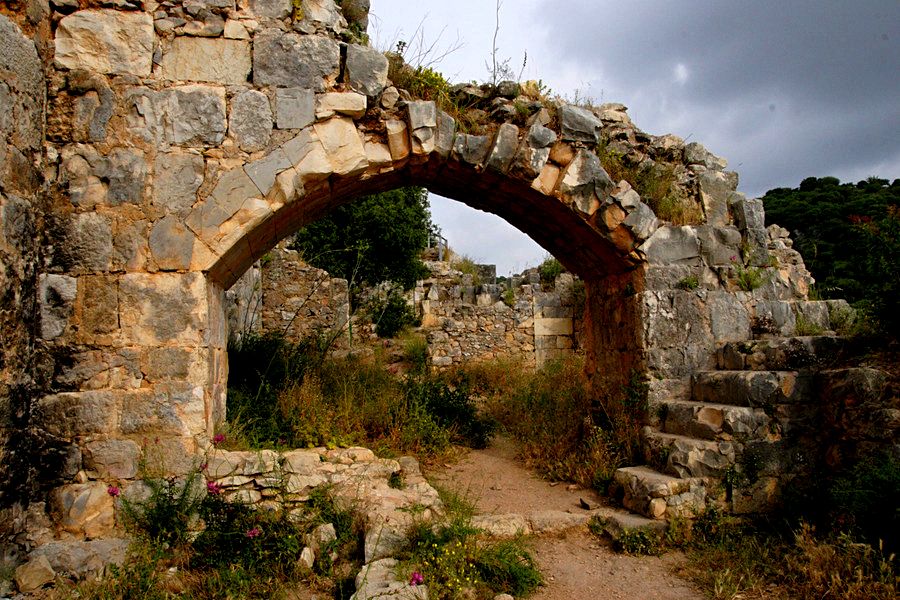
Montfort Fortress
In the 12th-century one of the richest noble Crusader families, De Milly, established a farm near where the fortress stands today. He owned property, villages and land in the area. In 1187, Saladin, Sultan of Egypt and Syria, captured the farm. It was reclaimed and rebuilt in 1192. In 1229, the Teutonic Knights bought the land. With financial help from Pope Gregory VI, the German Teutonic Knights built the fortress on the ruins of an earlier Roman fort. The Teutonic Knights were a Catholic military order founded in Acre to help protect Christian pilgrims in the Holy Land. The knights used the fortress as an administrative center, and for their archives and treasury. They built an inner and outer wall, but what remains are watchtowers and the fortress keep. At the rear of the structure, you can still make out where a moat once protected the castle from attacks. The tower at the northwestern gate is the most prominent part of the ruins.
Not long after construction, in 1266, the Mamluk Sultan Baybars laid siege to the fortress. But thanks to the castle’s defensive walls and the difficulty of navigating the rocky terrain, the Sultan’s attack failed. A few years later, in 1271, the Muslim ruler attacked the fortress again. This time the Mamluks broke through the southern outer wall. The Crusaders were trapped in the inner fortress. They surrendered, rather than lose their lives, their archives and treasury. The Sultan had the fortress destroyed, and it has remained unoccupied ever since.
Join Us
Keep in Touch


 Login / Register
 Contact


 Show On Map


 Certificate of Excellence
 Guaranteed Departure
 Low Prices Guaranteed
 24/7 Support