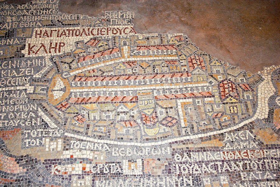
The Madaba Map is part of an ancient floor mosaic from the Byzantine Church of St. George in Madaba, Jordan. The map depicts the Middle East including the oldest surviving map of the Holy Land and Jerusalem. It dates back to the 6th-century AD and gives us an extremely valuable glimpse into the way Jerusalem looked over 1600 years ago.
Experts have managed to date the mosaic because it features the New Church of the Theotokos in Jerusalem which was dedicated in 542AD. And it does not depict any Jerusalem structures built after 570 AD. This gives experts a clear idea of the age of the map (542-570) and the appearance of Jerusalem at the time.
When the Church of St. George was constructed, Madaba was the seat of the bishop and the mosaic work would have been done by anonymous Christian artists. In 614, the Sasanian Empire (Persian) conquered Madaba. In the 8th-century motifs depicting living creatures were removed from the mosaic according to Muslim custom not to depict living creatures.
The city was almost completely destroyed by an earthquake in 746, and the mosaic remained hidden until 1884 when it was rediscovered during the construction of a new church on the same site. The church was completed but for almost a hundred years the mosaic was not protected or preserved. In 1964, restoration and conservation of the Madaba Map began thanks to the German Association for the Exploration of Palestine.
The mosaic shows the Middle East from Lebanon in the north to the Nile in the south, and from the Eastern Desert to the Mediterranean Sea in the west. Among the landmarks on the map are the Dead Sea, the Jordan River, Jericho, and Bethlehem. There are also images of fishing boats, fish, palm trees, a gazelle, and a lion. The landscape is labeled in Greek and the map uses biblical passages. In total there are 150 towns and villages on the map, all labeled with their names. The map is presented from an aerial and folding perspective.
The most impressive, and detailed portion of the map is Jerusalem which is placed in the center. The cityscape shows the Old City, Damascus Gate, Lion’s Gate, Zion Gate, Golden Gate, the Tower of David, Church of the Holy Sepulchre, and the Cardo, which was the ancient main route through the city. If you visit Jerusalem today you can still see the excavated Cardo in the Old City.
The map might have once been a guide to Christian pilgrims heading for the Holy Land, and Jerusalem. Today, the map mosaic remains on the apse floor in the Church of St. George at Madaba in the Kingdom of Jordan. With the passing of time, the mosaic has deteriorated from 21m by 7m to 16m by 5m.
It is still one of the most illuminating artifacts used for studying geography, history, and for verifying biblical locations. It is the oldest known geographic floor mosaic in the world. If you are not planning to visit Madaba, you can see a replica of the mosaic map in the lobby of Jerusalem’s YMCA building.
If you would like to visit Madaba, consider joining one of our Jordan 3-4 days tours.
Join Us
Keep in Touch


 Login / Register
 Contact


 Certificate of Excellence
 Guaranteed Departure
 Low Prices Guaranteed
 24/7 Support